After climbing to the highest point in South Dakota – Black Elk Peak – Diana and I continued further into Custer State Park. We moved out of hiker mode and into tourist mode, ready for an afternoon of scenic drives, overlooks, wildlife spotting, and Visitor Centers.

Our journey started at the Sylvan Lake Trailhead, where we’d parked to climb Black Elk Peak. From there, we began a 75-mile loop combining three scenic drives – Needles Highway, Wildlife Loop Road, and Iron Mountain Road. First up, Needles Highway, which begins just past Sylvan Lake. The Needles Highway winds through towering granite spires and pine-spruce forest on a downward journey toward the park’s lower elevations. There are numerous rock tunnels and scenic overlooks scattered along the way.

At just 8′ 9″ wide and 9′ 8″ tall, the Needles Eye Tunnel is the tightest squeeze of the park’s many tunnels. Traffic does go both directions here, so visitors had to work together to help vehicles pass through one at a time. This was a fun experience, but we were glad the other tunnels would be a bit bigger.


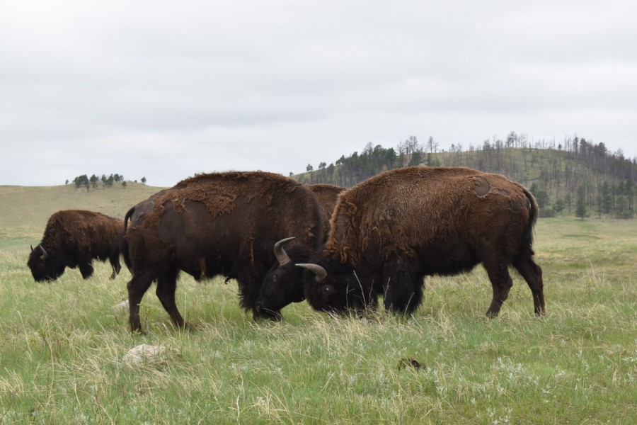
After the Needles Highway, we followed signs for Wildlife Loop Road. This scenic drive circles around the park’s grassy lowlands. As the name suggests, the chance for spotting wildlife on Wildlife Loop Road is pretty high, and while there are numerous wildlife species living in the park, the park’s herd of ~1500 American bison is the star attraction.
But before we got to that, we took a detour to the Mount Coolidge lookout tower. Unlike the lookout on Black Elk Peak, this lookout has a road all the way to the top. In fact, it’s still active and is currently used as a fire lookout and dispatch center. We were unable to go inside but we did walk around the observation deck.


Interestingly, while we were on Mount Coolidge, we were in between cloud layers. As the clouds moved, some of the distant hills showed their tops.

Continuing on our journey along the Wildlife Loop Road, we kept our eyes peeled for any signs of wildlife. There was always a possibility we wouldn’t see anything at all, but we had high hopes we’d get to see the bison. As it turned out, we saw hundreds of bison and their brand new babies, plus a few of the local burros.

A tip from the volunteers at the Wildlife Station Visitor Center led us on a short loop down some gravel roads through the bison area. This Visitor Center is a good place to stop if you want to see the bison. They keep records of where the various herds have been spotted so you can go see them for yourself. We took our time driving around and admiring the babies’ sweet faces. The bison aren’t afraid of vehicles so we were often very close to them. (Just don’t get out of the car!)


We finished up the Wildlife Loop Road at the main Visitor Center. This Visitor Center is brand new and huge. They have a wonderful video about Custer State Park, the bison herd, and the annual bison round-up. From there, we continued to the last of the three scenic drives, Iron Mountain Road. Iron Mountain Road leads back up into the forested hills and ends at Mount Rushmore National Memorial. There are some good opportunities to see Mount Rushmore along this drive.


We decided not to stop at Mount Rushmore since we’d both already been there (and we saw it pretty well along the drive), so we continued along the last leg of the loop back to the hotel. This wrapped up our Dakotas trip, all that was left to do was drive the six or so hours home the following day. The trip may have been short, but we did and saw a lot, and had many new stories to tell!
I would like to acknowledge that Custer State Park is on the ancestral land of the Očhéthi Šakówiŋ (Great Sioux Nation) and Cheyenne.
Chelsea

Pingback: Black Elk Peak (7,242′) | South Dakota’s State High Point | 05/22/21 – Colorado Chelsea
Wow! Great informative post. Love it! Thanks for posting. The pics are great!!!
LikeLike
Thank you so much 🙂
LikeLiked by 1 person
so different than our weather. We were there in July and it was as hot as heck. I actually sort of like the fogginess
LikeLike
We either had horrible luck or we managed to take our trip during the rainy season. It thunderstormed every night and was foggy every day. Though I think I prefer that to hot weather!
LikeLike
Love this! Great photos and info that bring back some happy memories of my time there years ago.
LikeLike
Thank you Tracy!
LikeLiked by 1 person
I love all the interesting rock formations. The gloomy weather just adds to the ambience. How awesome to see the bison so up close!!
LikeLike
I do think the fog made the rock formations look super cool! And I always love seeing bison, it was amazing to get so close!
LikeLiked by 1 person
Nice photos. We plan on going back to visit this park next summer.
LikeLike
Thanks Joe, that’s awesome!
LikeLike
I love the rock formations and that tunnel!! Cute baby bisons too 🙂 Maggie
LikeLike
The rock formations along the Needles Highway are SO cool. But yes, the highlight of the afternoon was definitely seeing the tiny babies 🙂
LikeLike
This looks like it was a great drive!
LikeLiked by 1 person
We cannot wait to go to South Dakota! The bison are so amazing to see no matter where they’re at. Love all the posts! And thanks for checking out our post about Devil’s Den State Park!
LikeLike
Thanks for reading! I hope you’re able to get out to see the bison soon 🙂 Colorado has a couple herds as well (but a LOT smaller)
LikeLike
Absolutely! We got to see the very small herd they have at Land Between the Lakes in Kentucky when we went (have a post on that on our blog) and even that was really cool.
LikeLiked by 1 person
I’ve visited the area twice for the great climbing it has to offer. While a bit scary with potential dangerous falls, the climbing is excellent.
Mount Rushmore evoked mixed feelings for me. It’s impressive to see men’s engineering and artistic skills, but at the same time, saddens me to see the damage we can do to nature. It was a different era and a great help to the American economy during hard times.
My second trip was during the Sturgis Bike Rally. That also evoke mixed feeling.
Eman http://www.teach512.com
LikeLike
Thank you for sharing your experiences! I feel the same way about Mount Rushmore. It’s cool to see, but sad that the mountain was forever changed.
LikeLike
Hi Chelsea! I have a post scheduled to publish this coming Sunday!
Also, my wife and are heading to South Dakota and Yellowstone this summer!
LikeLike
That’s great! I will watch out for your post 🙂
Have fun on your trip! I look forward to seeing your pictures!
LikeLiked by 1 person