
Ouray Perimeter Trail | Uncompahgre National Forest
Ouray, CO | 05/01/21 | 6.36 miles | 1,763′ gain

Allie and I decided to spend our only full day together in Ouray; hiking, eating, and warm spring soaking. We’d both done a bit of hiking around town but neither of us had completed the Ouray Perimeter Trail, one of Ouray’s more popular trails. As the name suggests, the Ouray Perimeter Trail encircles Ouray, offering great views of the town itself and the surrounding mountains.
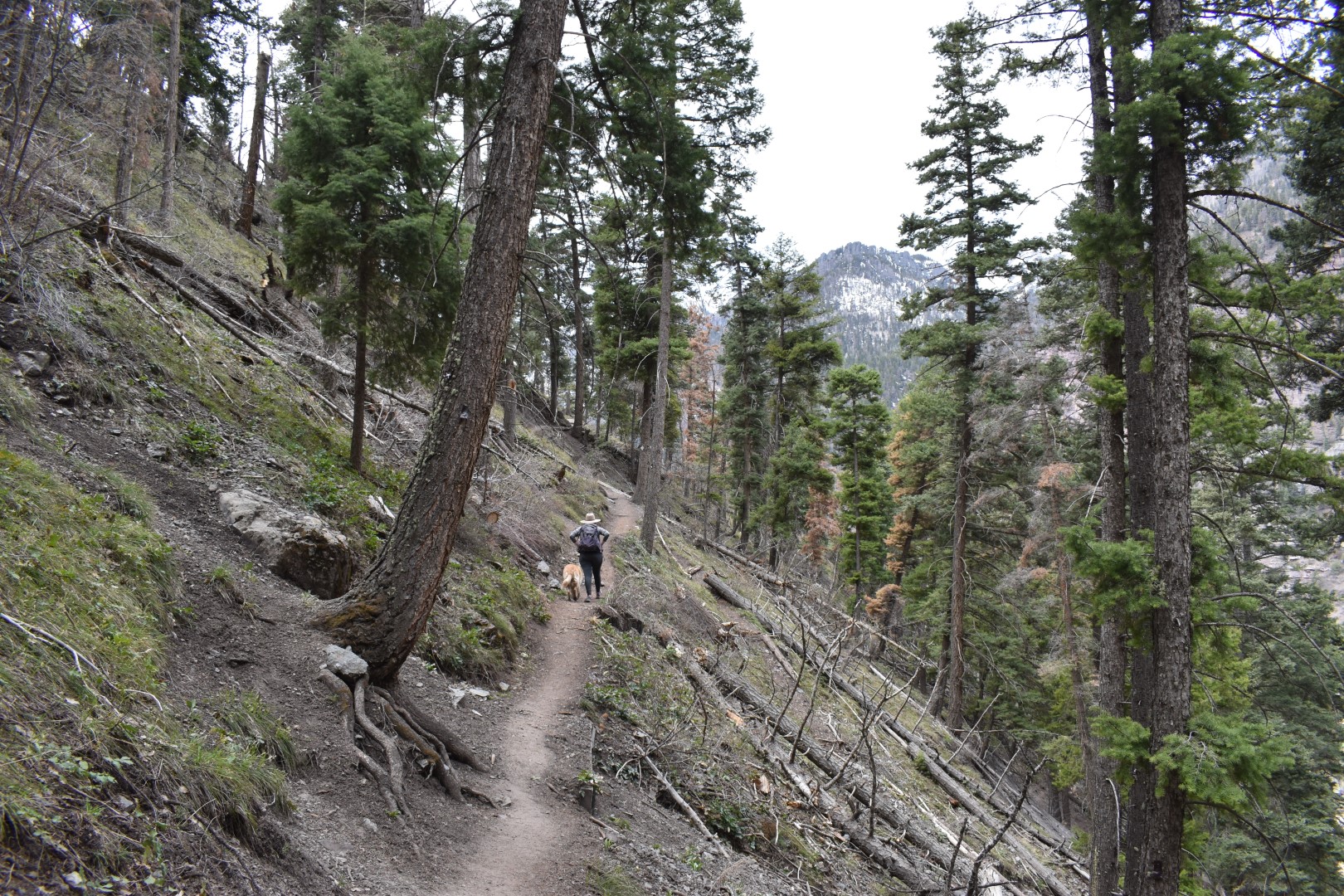
We parked at the Ouray Visitor’s Center and crossed the highway to get to the start of the Perimeter Trail. It seems most people start here and hike clockwise as we did, though there are plenty of alternate parking options along the loop. The trail doesn’t waste any time getting hikers above town, beginning with a stiff climb up a series of switchbacks. The views started early and continued throughout most of the hike.

Soon after the switchbacks, we spotted a mine on the cliffs above us. In a constant effort to poke our heads into every mine hole, our attention left the planned hike and moved to “how can we get into this mine?” A faint climbers trail led up the steep, loose slope to the base of the cliff. From there, it looked possible to scramble up the initial rock face and follow a ledge to a log that was placed to access the mine platform. Allie scrambled up to check it out while I stayed with Harper. While this may have once been safe access, it did not look safe for us this day. Our decision was reinforced when a pair of local rock climbers mentioned it required climbing gear to get up there.


Back on the trail, we continued around the cliffs. We did not see any more mines.


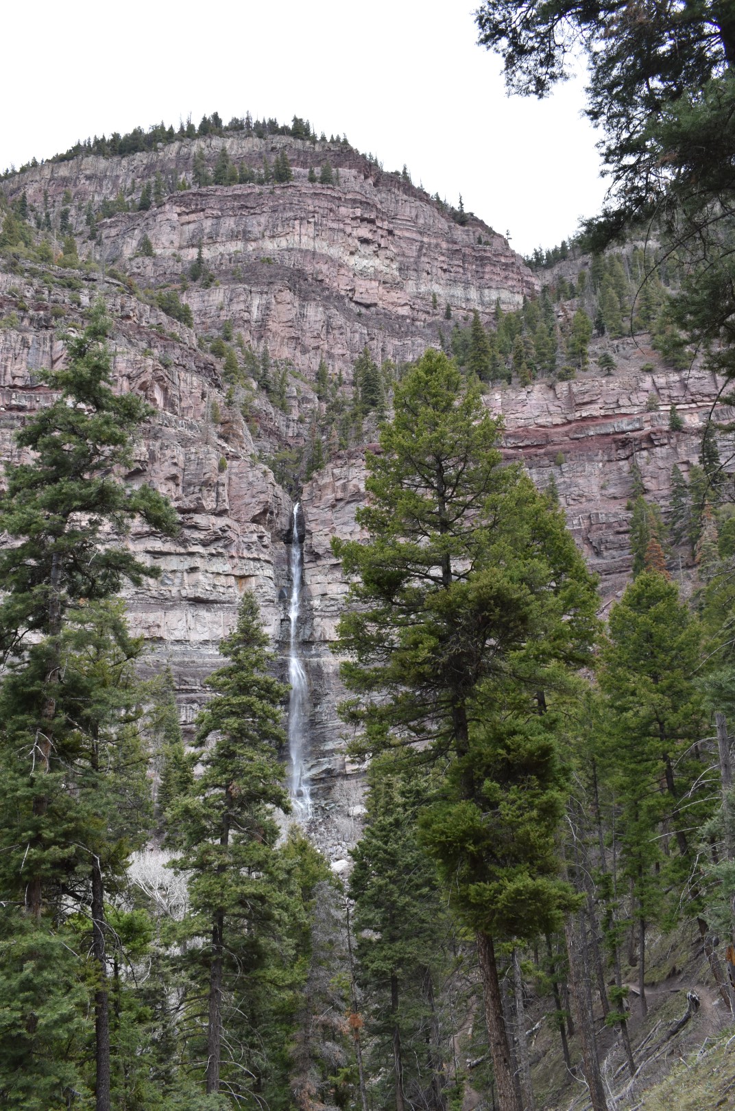
The next stop on the loop was Cascade Falls, which I visited back in 2019. Since it has it’s own nearby parking, the falls were swarming with people.


The trail switchbacked down below the falls and crossed Cascade Creek before climbing up the other side. This was the first of many ups and downs along the loop. We stopped at the creek to let water-dog Harper go for a swim.

Back in the forest, we continued our climb towards the high point of the loop. So far the trail had been well-marked, but the trails and roads around the Amphitheater Campground were very confusing. There were few signs and it wasn’t always easy to know which way to go. Without our pre-downloaded AllTrails map, we surely would have went the wrong way many times.

I somehow managed to not get any pictures of the Baby Bathtubs on Portland Creek, and with a name like that you’d think I would have done better! (But you can see some pictures here.) The Baby Bathtubs are oval-shaped holes carved into the bedrock by water, which seem to be the perfect size for a baby’s bathtub! Like Cascade Falls, the Baby Bathtubs have their own parking area and were very busy. We found a quiet spot up the creek a ways for our lunch break.
We were really hoping to see some spring wildflowers, particularly pasqueflower and claret cup cactus. Our wish was granted when we reached a meadow near the high point of the trail. The meadow was carpeted in pasqueflower and spring beauties. We hunted for claret cup cactus and found a few but they weren’t yet in bloom.


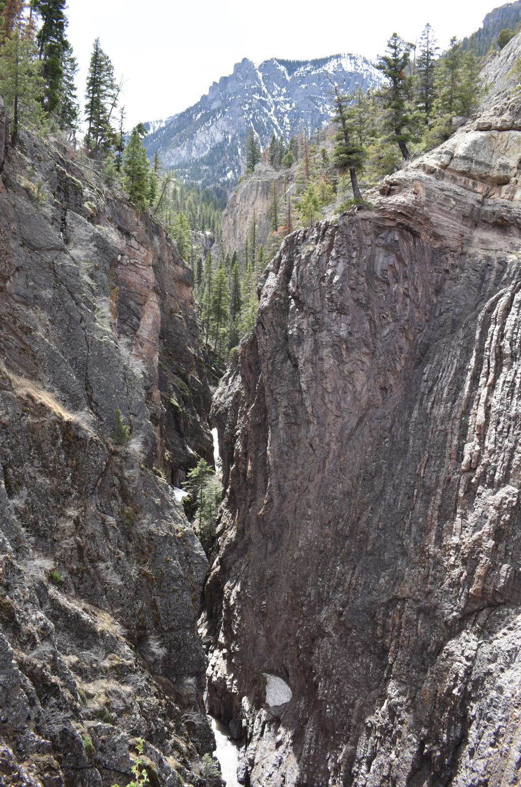
From the high point, we descended a few hundred feet to the highway and crossed for a second time. The trail cuts south here, heading away from town as it wraps around the Ouray Ice Park. Except for the gorgeous Uncompahgre River Gorge, this section of trail was uneventful.


Once past the ice park, we crossed a dirt road near the start of the Sutton/Neosho Trail. After what had so far been a fun hike with a lot to see, we expected the rest of the loop to be mediocre at best. We soon realized that would not be the case. The trail popped out of the forest at the Box Canyon Footbridge, high above Box Canyon Creek. Somehow neither of us knew this was coming and it was an awesome surprise.

I’m pretty afraid of heights so I didn’t love crossing the bridge itself, but I kept my eyes focused on what was just on the other side of the bridge.
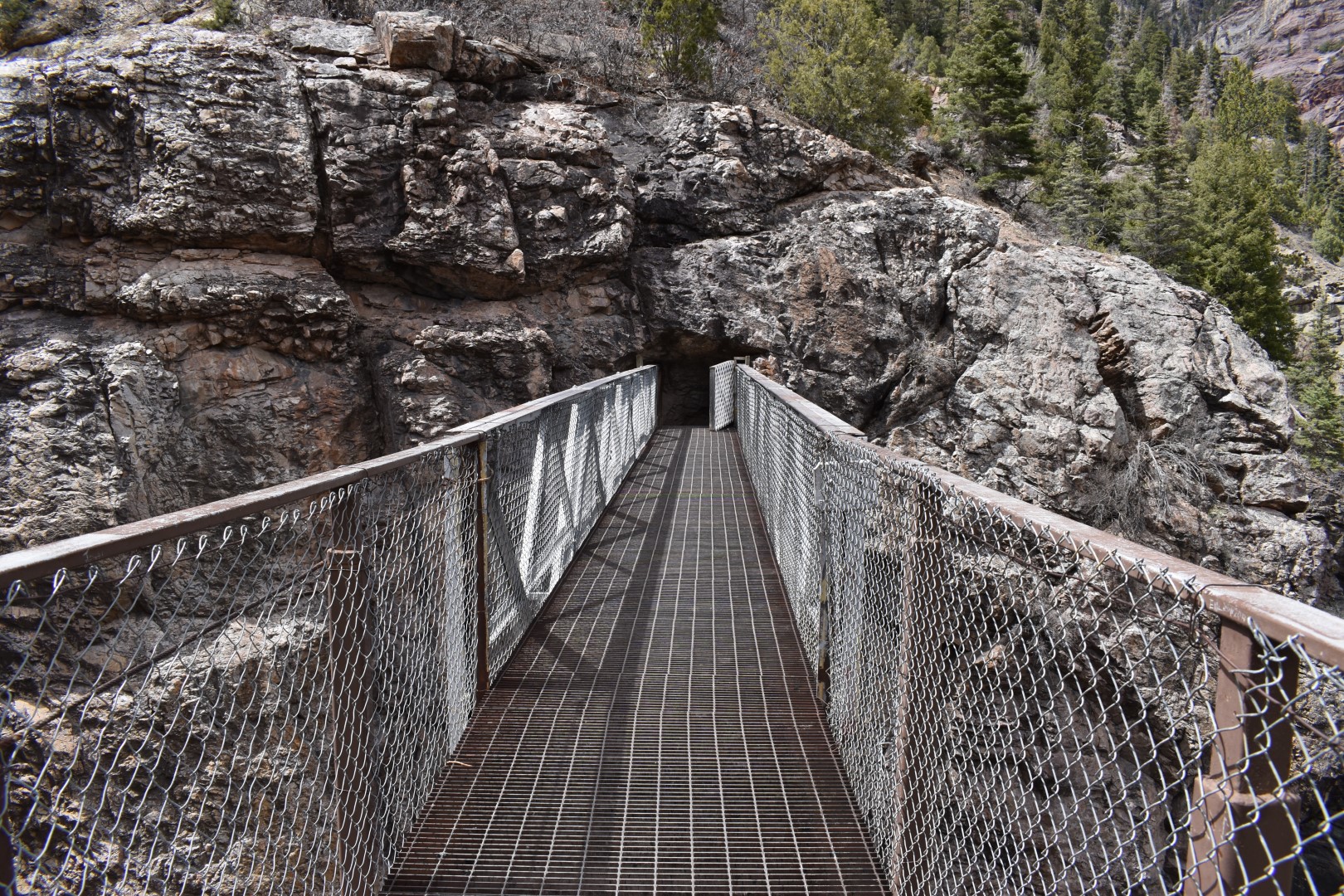
Just below us in the canyon was the Box Canyon Falls Park. We couldn’t see much from above but we could occasionally see some of the park’s red walkways. For a small fee ($5/person as of 2021), visitors can walk through the canyon to see Box Canyon Falls. There is a connector from the bridge down to the park but dogs aren’t allowed (nor had we brought any money) so we continued on instead. The bridge led directly to a tunnel in the rock face, possibly once used by miners. It wasn’t very long but we had a lot of fun. The bridge/tunnel combo was the highlight of the hike for us.


After the tunnel, the trail descends a steep set of stairs before heading back up again on a dirt road and then down once more on a trail to Oak Creek.


Past Oak Creek, we climbed up one last time before making the final descent back to the car. This last section of trail felt very long and didn’t have much for scenery, particularly the last bit which was on a road through a campground and neighborhood.

We eventually worked our way back to the Visitor’s Center and grabbed a quick early dinner in town before driving south on the Million Dollar Highway to a wild warm spring. It was barely warm and pretty stinky and slimy, but we soaked our feet for a little while. (It turns out we had just missed a much nicer warm spring nearby, but I thought the bathtub was cool!)

A soak in a stinky, not-even-lukewarm spring was an interesting end to a fun day in Ouray. We both liked the Ouray Perimeter Trail so much that we agreed it’s a hike we could do every spring while we wait for the snow to melt up high.
I would like to acknowledge that the Ouray Perimeter Trail is on the ancestral land of the Núu-agha-tʉvʉ-pʉ̱ (Ute) and Pueblos.
Chelsea

🙂 Wow You saw most everything, neat shots 😉
LikeLiked by 1 person
For a short hike, there is a lot to see! Thank you 🙂
LikeLiked by 1 person
Good hike. I’ve been in the area a number of times and I did not know about this trail.
LikeLiked by 1 person
I can’t even tell you how many times I’d almost hiked this trail but decided to do something different. I shouldn’t have waited so long!
LikeLike
Looks like quite the hike Chelsea. A lot of interesting things to see. The tub looks cool, but not the stinky foot soak. Cheers. Allan
LikeLike
The soak was gross, but feet can be washed LOL
LikeLike
excellent experience lots of exciting adventures great post love your vibes from your writing very peaceful looking place love your beautiful pictures I Listen do to my Dyslexia… Blessings 🙌 be
LikeLike
Thank you Ben!
LikeLike
This looks like such an interesting hike with having to cross a large pipe and walk through a tunnel. That bathtub looks a bit sketchy, but also pretty cool.
LikeLike
There was always something interesting around the corner on this hike! And we took showers as soon as we got back LOL
LikeLiked by 1 person
When we visited Ouray we visited Box Canyon Falls Park – after two beers – we were sweating and sober by the time we reached the bridge. I would love to go back and spend more time in Ouray and do the full loop! Great pictures!
LikeLike
The loop is definitely worth doing! I’m excited to get back and actually visit the park itself.
LikeLiked by 1 person
Here are the pictures from our visit if you are curious. https://mcgeetraveltales.com/2019/11/09/colorado-box-canon-falls-park/
LikeLike
Thanks for sharing! I didn’t realize the falls were so hidden.
LikeLiked by 1 person
A. I love this trail!
B. Harper is so stinking adorable
C. How in the heck did that person get up behind Cascade Falls like that?
LikeLike
There’s a ledge (the one I was on in the pic of me & the falls). I don’t remember it looking horribly safe to get back there but I guess that person’s comfort level is higher than mine LOL!
LikeLiked by 1 person
Very nice! I love this area and hope to spend more time out here as we start planning retirement! ( ok, a few years yet but I’m making a list)!
LikeLike
Are you relocating out here or just planning to travel more?
LikeLiked by 1 person
We plan on spending a month or so each summer or fall in different areas of Colorado! We had thought of moving out there but the housing costs and winter! We bought a lot in NC where we will officially retire at. Looking at 3-5 years! My son and his wife are expecting a baby in February so I am sure I will be coming out that direction more often and of course I will be sneaking a hike or two in!
LikeLike
That sounds so fun! A month is a great length of time, you’ll be able to get a lot done! I’m sure North Carolina will be a wonderful spot to explore in retirement too 🙂
LikeLiked by 1 person
Hoping it all goes as planned! As I wait though, I’ll keep marking your posts and referencing where to go!!!
LikeLike
Aw yay! Definitely reach out if you need to! And I can always make time if you need a hiking partner 🙂
LikeLiked by 1 person
I will remember that! Thank you!!
LikeLiked by 1 person
What an interesting hike! We don’t have anything like that here that I can think of. The tunnels look like fun and Cascade waterfall is beautfiul. Maggie
LikeLike
Ouray is pretty unique! I’ve never been to another town like it. It’s locally known as “America’s Switzerland”, so I wonder if Swiss towns may be similar (I have never been there).
LikeLiked by 1 person
Quite a beautiful landscape and trail with unique features. Glad you didn’t fall!
LikeLike
It’s such a beautiful area! Thanks for reading 🙂
LikeLiked by 1 person