
Lenawee Mountain (13,204′) | CO Rank: 484/637
“Southwest Lenawee” (13,180′) | CO Rank: Unranked
Front Range | White River National Forest | Montezuma, CO
07/12/20 | 9.22 miles | 3,211′ gain | Class 2+

Lenawee Mountain (pronounced len-uh-way) was one of those mountains that I was really excited to climb. Its proximity to Denver and its rugged south ridge make it popular for a 13er, but even that couldn’t deter me. Lenawee is a huge mountain with a number of sub-summits, all falling under the umbrella name of “Lenawee”. Two of these sub-summits are over 13,000′ and those were the two we were aiming for; Southwest Lenawee (an unranked 13er) and the true Lenawee Mountain, the highest point at 13,204′.
The standard way to climb Lenawee Mountain is an out-and-back hike; follow the Lenawee Trail, summit Southwest Lenawee first, then traverse the rugged ridge to Lenawee, and finally retrace your steps back down. We wanted to follow this route up, but Allie (my partner on this hike) did some extra research in Derek Wolfe’s book “Colorado’s Front Range Thirteeners” and found an easier route down. This would ultimately save us from scrambling along the ridge a second time. The only problem was that we had just two short paragraphs in a book to describe this descent.
We were expecting noon thunderstorms so we arrived bright and early at 6am. Hopefully this would give us enough time to get back down to the trees before the storms hit. The Lenawee Trailhead is small but marked, just off Peru Creek Road. This is a rough dirt road, high clearance is recommended.

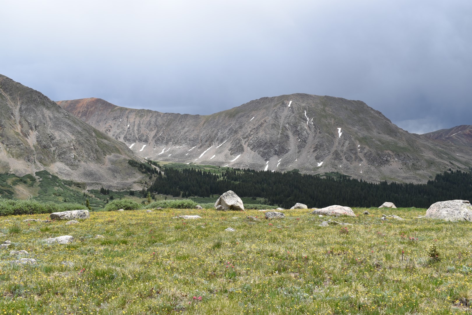
The Lenawee Trail starts from the small parking area and angles up a large slope. It’s a steady incline the entire way and totally forested. This section of trail is well traveled and easy to follow. We passed an avalanche path, a few small streams, and some dilapidated mining ruins.


Once we reached treeline, we caught our first glimpse of Southwest Lenawee. While the mountain itself is pretty, we found the views into Thurman Gulch to be particularly scenic.


We continued on the trail until about 12,200′ where we turned off and began ascending Southwest Lenawee’s grassy slopes. We each picked our own line; Allie went straight up to the ridge and then followed that to the summit, while I did more of an ascending traverse. We were never out of eyesight of each other.


It felt a lot steeper than it looked and this ascent took us quite a while. I met back up with Allie on the ridge just below the summit. The views from here were incredible. We could now finally see the true summit of Lenawee as well as much of our remaining route. We made sure to scope out our descent off Lenawee while we had a good view of it.


The route description we had for the connecting ridge was generic; descend to the saddle and then ascend the other side, keeping left as needed. The ridge was easier than it looked and we took everything one step at a time. We did have the added difficulty of ensuring we found a route that the dogs could follow, but otherwise nothing was too difficult. Whenever the scrambling got too difficult or the exposure to the right too extreme, we simply dropped down to the left to find an easier way. We were often on a faint trail.


We were able to keep our route difficult Class 2 with a few Class 3 moves sprinkled in. We didn’t try too hard to find an easier way as this was well within our abilities, but with careful route-finding the ridge can supposedly be kept at difficult Class 2.


Lenawee made 13er #5 for me this weekend and I was especially proud of having climbed so many in just a few days. We had some time for a snack on the summit but we knew we needed to get moving before the storms hit. We reviewed our brief route description as well as the photos we’d taken of our descent route earlier. Armed with that and a map, we struck out to find what would hopefully be an easy descent route.

We descended grassy slopes southeast of Lenawee’s summit. We were looking for an entrance to a series of steep, grassy gullies that would allow us safe passage to Chihuahua Gulch. It was important to find the exact descent point to avoid cliffs further east.


Thankfully we found the grassy gullies immediately and were easily able to link up gully after gully on our descent. Most of them were pretty easy, though steep, but a few had some loose dirt that made the going a bit slower.

Our first landmark after the gullies was the unnamed lake, and we picked our way over grass, talus, and streams to get there. One larger stream crossing choked by willows proved problematic but we eventually found a goat crossing (evidenced by clumps of white mountain goat fur) that was much easier for us to hop across.


We spent some time at the lake to water the dogs and rest our feet, but the storms were approaching and we really needed to get a move on. Our reference book “Colorado’s Front Range Thirteeners” mentioned that one could drop down east from the unnamed lake and with an easy bushwhack, reach the Chihuahua Lake Trail. Just based on the forest and marsh in that area, we guessed the bushwhack wouldn’t really be all that easy so we contoured northeast from the lake, staying above treeline (and above any potential bushwhacking) until we ran into the trail. This added more mileage to our hike, but was overall much easier.
The Chihuahua Lake Trail started narrow but soon widened into an old road. We passed the Chihuahua Lake 4wd trailhead and then a ton of 4wd vehicles and some hikers heading back to the 2wd trailhead. Chihuahua Gulch is extremely pretty and the number of people indicated we weren’t the only ones who thought so. The road was easy to follow, though of course felt insanely long. There were a number of wide stream crossings that were meant for 4wd traffic (wide and shallow) with nowhere for hikers to cross. Wet feet were unfortunately inevitable.


We soon reached Peru Creek Road and from there it was a very short walk to the Lenawee Trailhead. It sprinkled on and off but at least it waited until we were safely under the cover of forest. What a great day and an absolutely epic loop, wet feet and all.
Chelsea

Gorgeous photos that made me feel as if I hiked with you. Thank you for sharing!
LikeLike
Thanks Tracy! This one proved tough for me to write so I’m extra glad that you were able to “hike” along with me.
LikeLiked by 1 person
Love the photos! Man you guys were way up there, nice views. I have tried to plant Indian paintbrushes here in Wv but my soil isn’t so great. Thanks for the obits!
LikeLike
That should say thanks for the photos, thanks Siri lol
LikeLike
Haha!! It’s too bad we can’t edit WordPress comments…that would be nicer for accidents like this lol. Indian paintbrush are parasitic and are notoriously hard to grow in a yard/garden. (I’ve never tried, just what I’ve heard.)
LikeLiked by 1 person
A friend of mine hiked Chihuahua Lake this summer and told me it was her favorite hike of the year… given the scenery I think I see why she feels that way. Such pretty views and I especially love the ruggedness of the mountains! This is making me excited for some off trail 13ering (let’s pretend that’s a word) next summer 😃
LikeLike
Even I wanted to hike to Chihuahua Lake after this loop! Haha, it’s sooooo beautiful up there. I definitely call it 13ering so it must be a word 😉
LikeLiked by 1 person
Absolutely beautiful pictures, and your furry friends are very cute.
LikeLike
Thank you! 🙂
LikeLike
beautiful photos, thanks for posting
LikeLike
Thank you! 🙂
LikeLike
Beautiful!!!
LikeLike
Thank you!
LikeLike