
Balanced Rock Trail | North Sterling State Park
Sterling, CO | 04/18/20| 0.34 miles | 45′ gain
The goal was to find a place to hike with as few people as possible (due to coronavirus). Heading east (the opposite direction of the mountains) is a surefire way to avoid anything that could even resemble a crowd. North Sterling State Park boasts miles of trails (plus it’s a decent drive) so we easily filled up an entire day.
I have an annual state park pass so Kyle and I were able to drive directly to the trailhead without stopping to pay a day use fee. I’d researched the various trails within the state park, and while we wouldn’t be able to finish all of them in one day, we could finish all of the shorter ones. I was most excited for the 1/4 mile Balanced Rock Trail as it was supposed to have a pretty cool fossil. That was our first stop.


Dam Trail | North Sterling State Park
Sterling, CO | 04/18/20| 2.54 miles | 14′ gain
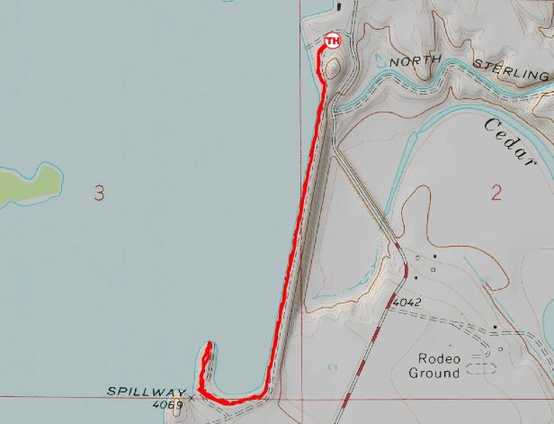
We next walked south from the Balanced Rock Trailhead on the Dam Trail. This trail follows the entire North Sterling Reservoir Dam before turning west and ending in the boat launch parking lot. The boat launch was closed so we walked all the way to the boat ramp to let Bob go for a swim.

The dam was constructed in 1911 to supply irrigation water to the surrounding farmland. It took two years and 1,500 mules and horses (plus their humans) to excavate the reservoir and build the mile-long dam. This area is semi-arid and without supplemental irrigation, crops would not survive. Today, the reservoir supplies water to 41,000 acres of nearby cropland.


South End Trails | North Sterling State Park
Sterling, CO | 04/18/20| 2.95 miles | 115′ gain
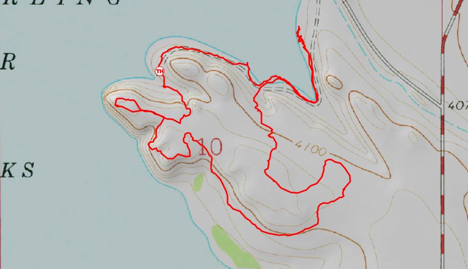
Just south of the dam are a number of short trails. (The state park calls these the South End Trails.) They don’t technically connect but we were able to make a decent loop out of all of them by occasionally following and crossing various campground roads.
We parked at Sunset Cove and had a quick lunch. After studying the map, we decided to head north on the Swim Beach Trail first. This trail leads from Sunset Cove past the Swim Beach and continues around another large cove before dead-ending at a day use parking lot.


The swim beach was completely underwater. I wonder what it looks like in summer! We continued around a forested cove. This was a really interesting area, almost like a swamp. The waves on the reservoir broke at the first line of trees, keeping the water towards the back of the cove nice and calm. This area clearly provides a ton of habitat for birds, as the sheer sound of them singing and squawking was deafening. It felt like we were in the jungle. How does this even exist in northeastern Colorado?


From the end of the Swim Beach Trail, we had to backtrack a short ways before connecting with the Chimney View Trail at the opposite side of the Swim Beach parking lot. We crossed a road and soon reached the Chimney View Campground. We were still in the beginning of lockdown and all campgrounds were closed. It was a little eerie walking around this huge campground with no one around. We wandered around the campsites and headed east to pick up the Amphitheater Trail. This is a short trail that leads from one parking lot to another (and to an amphitheater) and then we walked west through the also empty Inlet Grove Campground. Wandering through empty campgrounds isn’t exactly my favorite thing in the world, but then we reached the Shooting Star Trail and it became a bit more scenic again.

We followed the Shooting Star Trail up a small hill and connected with the Red Fox and Sunset Point Trails. These form two small loops at the top of the hill that provide good views of the reservoir.


After looping around Sunset Point, we crossed another parking lot to connect with the Sunset Cove Trail which led us back to our car. North Sterling is definitely not the most scenic or exciting state park in Colorado, but it was worth the drive to avoid the crowds and explore a pretty unique area!
Chelsea

I like the idea of mini hikes!
LikeLike
Me too! I don’t always want to do a super long hike (and some people can’t at all) so I like sharing short ones too!
LikeLike
Wow. Never been anywhere that looked like that! Awesome photos. And what a beautiful dog 🙂
LikeLike
It’s a pretty weird place haha! The reservoir is totally man-made, so I think that’s what’s made it look so different. Otherwise I think it would just look like the surrounding grassland!
LikeLiked by 1 person
Just dreamy! A big part of South Africa looks like this, these pictures remind me of Sunday afternoon walks with with our 8 dogs 🙂
LikeLike
That’s really cool! I would have never guessed a part of Colorado looked like South Africa! Isn’t it funny that places halfway around the world can look totally similar?
LikeLike
beautiful pics. Sounds like a great hike
LikeLike
Thank you! It was a fun day 🙂
LikeLike
Great hike. Awesome fossil!
LikeLike
Thanks for reading! 🙂
LikeLike
Definitely different than some of your other hikes that I’ve looked at, but no less interesting! Bob looks like he’s an avid hiker too. My daughter has a collie/blue heeler mix and they are sure smart dogs…rascals too 🙂
LikeLike
Yes, rascals are a good way to describe them! Bob has some joint issues now so he can’t walk as far as he used to, but he still loves getting to go!
LikeLiked by 1 person
Finding a place to hike that isn’t crowded has become a bit of a challenge these days. Looks like you found a lovely spot that wasn’t very busy.
LikeLike
Yes it is! We have been driving to the middle of nowhere to avoid crowds.
LikeLiked by 2 people
Awesome adventure
LikeLike
Thank you!
LikeLiked by 1 person
Nice photos!!! The dog is so cute. Colorado is so beautiful.
LikeLike
Thank you!
LikeLiked by 1 person
Nice photos, Chelsea. They make we want to go back. We camped there once years ago, but didn’t really do any hiking. I hope to remedy that oversight at some point!
LikeLike
Thanks Tanja! There were a ton of birds when we went as well, I think you’d enjoy it!
LikeLiked by 1 person
I remember the birds, Chelsea, but when we were there, I was just learning about them. I would love to go back to see how many more I would recognize now.
LikeLiked by 1 person
Mini hikes are the best!!! They get you out there and moving and seeing nature without feeling the crunch of having to push big miles. Its just a number. The experience is what matters!
BTW- Bob is AWESOME!!!
-Michael
LikeLike
Yes, they’re so fun! Thanks Michael 🙂
LikeLike
Pingback: South Shoreline Trail | Colorado | 11/27/20 – Colorado Chelsea
I live near a place called Brimham Rocks in the UK. One rock is taller and much wider than a person but at the bottom is about an inch in the middle touching the ground and just eternally balancing like that!
LikeLike
That’s so cool! I can’t believe rocks can balance like that.
LikeLiked by 1 person
I should really do a post sometime. I’ll try and get back there but it’s one of those places that’s always crowded now!
LikeLike