
On Monday morning, we woke up early to visit somewhere very special: Kartchner Caverns State Park! Phones and cameras weren’t allowed on the cave tour so I won’t go into great detail about it, BUT I just want to say that if you find yourself in Tucson, go do a cave tour at Kartchner Caverns! The caverns are amazing and the tour is totally worth the $23 per person.
After a morning at the caverns, we headed for the east side of Saguaro National Park. Just like the west side, we had way too little time to see the park but we did get to sneak in a few hikes and a ton of overlooks. As always, the visitor center was our first stop. The Rincon Mountain Visitor Center has a number of exhibits as well as a short trail around the building. Once we were done there, we set out on the Cactus Forest Loop, a scenic drive with numerous trailheads and overlooks along the way.


Desert Ecology Trail | Saguaro National Park
Tucson, AZ | 02/17/20| 0.29 miles | 10′ gain
We stopped to do a quick nature trail along the Cactus Forest Loop. The Desert Ecology Trail is a short interpretive loop that visits a number of different plant species. I found the interpretive signage and views from this trail to be lacking, and I wouldn’t recommend this trail unless you only have time for something very short.


Loma Verde Loop | Saguaro National Park
Tucson, AZ | 02/17/20| 4.71 miles | 210′ gain
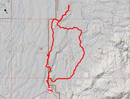
After a not so exciting trek on the Desert Ecology Trail, we were hoping for better luck along the Loma Verde Loop. This is a loop that the NPS website recommended. It creates a loop from the Loma Verde (west), Pink Hill (north), and Squeeze Pen (east) trails. If you look closely at my map, you can probably see we missed our turn off and went too far north (oops).

The Loma Verde Trail heads north from the trailhead into the cactus forest. The surrounding landscape was full of gorgeous cacti and we had views of the neighboring mountains most of the time.


The trail was easy to follow and mostly flat but we found ourselves taking our time to look at each individual cactus. We’d seen a picture of a seedling saguaro at the visitor center and really wanted to find one, but the smallest saguaro we found was about 12″ tall.

A sign on the trail leads to a short detour to the Loma Verde Mine. The 350′ mine shaft was dug by the Loma Verde Copper Company in 1901. Although they found 16% copper ore, the mine soon closed. Copper ore can be found scattered around the site.


After an extended stop to hunt for copper ore, we continued along the Loma Verde Trail only to miss our turn on the Pink Hill Trail. This area is covered in a network of criss-crossing trails, and while all of the intersections are marked, some of the signs don’t make any sense or don’t match up with the park map. Eventually we figured out that we were going the wrong way, and some trail riders gave us better directions than what we had. Soon enough, we found the Pink Hill Trail and were back on track.


The Squeeze Pen Trail was easier to find and that took us all the way back to the trailhead. It was pretty warm out so our hike felt like it was taking forever, but in reality we were only on trail for two hours.


I was so happy to see flowers blooming (although I didn’t know what they were at the time) and we were very excited to find a Cristate Saguaro. We’d read about this unusual growth habit at the Visitor Center and hoped to see one for ourselves. They are supposed to be pretty rare! After finishing up the loop, we continued our drive through the Cactus Forest. A few more overlooks and we were too exhausted from our long trip to do anything else.


Such a fun trip to visit two states, two national parks, one state park, and a national monument. A busy trip jam packed with hikes and adventures. I can’t wait for the next one!
Chelsea

Great post! This is all stuff we did not do so I really enjoyed reading about it. Sorry the Ecology Trail was a bust …
LikeLike
Thank you! It happens, not every trail can be awesome! But they’re always worth a try 😀
LikeLike
I went on a cave tour through Kartchner Caverns about five years ago and remember being very impressed with all the interesting cave formations. Unfortunately I didn’t have enough time in Arizona to go to Saguaro National Park. It’s too bad because it looks like there is pretty decent hiking there. And who doesn’t enjoy looking at all the different types and shapes of cacti?!
LikeLike
Right!? We love cacti! We have friends in Phoenix who we visit every year, so I’m sure we’ll be back! Thankfully, because we had barely any time to do anything :(. I hope you can make it back one day!
LikeLiked by 1 person
Loved the Saguaro in your pictures as that is not the type of cactus I see in CA or NV.
LikeLike
Thank you Roger! They are pretty unique, we love all the different shapes they can form!
LikeLike
Saguaro was supposed to be our next National Park (after Yosemite and Pinnacles in March), but circumstances intervened. When we do get there, this will be one of the resources we use to plan!
LikeLike
Oh no, I’m so sorry to hear that! This is not a fun time for those of us who have the travel bug…hopefully everything gets back to “normal” soon and you can reschedule your trip! I’m glad I was able to help you a bit with your planning 🙂
LikeLiked by 1 person
I am jealous! Beautiful pictures
LikeLike
Thank you! 🙂
LikeLike
Thank you for sharing your beautiful photos. You visited one of our favorite places – Kartchner Caverns State Park. It is a magical place. ✨ We had the pleasure and honor of attending the Park’s 20th Anniversary celebration last November. A memorable evening and always a memorable tour. ❤️
LikeLike
That sounds wonderful! If we lived nearby, we’d definitely be frequent visitors. Thanks for reading!
LikeLiked by 1 person
I loved visiting this area and seeing the cacti! There is something so majestic about the Saguaros! I found them absolutely stunning.
LikeLike
The desert is such a fun place to visit! Love the saguaros 😀
LikeLiked by 1 person
The saguaros are beautiful but I would not want to get lost in the desert. Under such austere condition, what natural objects might be used as markers to retrace your way if needed?
LikeLike
I would definitely not want to get lost in the desert either! Thankfully we were on a front-country trail with tons of people, signs, and intersections, so truly getting “lost” is pretty unlikely (at least for us). We could have just turned around and walked out the way we came instead of creating a loop, assuming we couldn’t find the appropriate turnoff.
I can’t exactly answer your question because I do always hike with some level of preparedness with maps and such, but I tend to take a ton of photos for my blog, so worst case I would have photos of potential markers. Also obvious things like intersections, bodies of water, unusual rock formations, mountains, etc could be easily remembered.
When I visit popular trails like this, I don’t prepare as much as I would for, say, a backcountry 13er with no trail that’s climbed by only ~10 people each year. For that, I will have at least one electronic map (I use gpx files on Gaia most often so I can see where I am compared to the route), route photos if available, plus I track my route using Strava on a second phone (which acts like another map). A compass would be a great idea (and the knowledge of how to use it). I’m also usually with a friend who has a GPS unit with a texting feature if we do get into trouble. My husband and her boyfriend always know where we’re going and what time we should be back as well. All of that preparation is pretty standard for back-country travel, but I do about half of that for front-country trails, just enough to make sure I know where I’m going and someone else knows where I am.
I hope that answered your question!
LikeLike
Despite your photos and descriptions, I have a feeling that the first time I see a Saguaro for myself I will be blown away by how massive they are. Thanks for taking me on a tour of a new park 🙂
LikeLike
I’m sure you will love them…they are so fun to look at!
LikeLiked by 1 person
Fascinating to read your post. We live in the area. This spring was one of the most amazing wild flower seasons ever. But sometimes you have to look closely, many flowers are small. You should have seen some on your visit in February. So glad you enjoyed your visit! 🌵🌵
LikeLike
Thank you! I don’t remember seeing a ton of small flowers, I think we were just slightly too early. (Or maybe we just weren’t looking in the right spot!)
LikeLiked by 1 person