
Hello! Thank you so much for reading my blog. I’ve had a few requests to include maps in my posts and I’m testing this out. Please let me know what you think! Drop a comment below or contact me via email. I appreciate any and all feedback (about the maps or anything else!) and I will do my best to make my blog more useful to all of you. I plan to include maps in all future posts and if anyone seems to find them helpful, I will likely go back and add them to my old posts as well. Thank you and enjoy!
Now that we’re mostly housebound, I’m sad to be finishing up my blog posts from our February trip. We had a number of small trips planned for this year that may need to be postponed, and right now we’re doing the best we can just to get outside at all. Parks and trails are closing and soon it may be required that we stay home even more than we already are. We are in strange times indeed!
But this post isn’t about coronavirus. In fact, these hikes took place before coronavirus was even on our radar. This was our last morning in Joshua Tree National Park. We only had a few hours before it would be time to head to Phoenix for our friend’s birthday party. We hadn’t done much in the center of the park yet and an early morning start (before the crowds) would be a perfect time to visit the busiest section of the park.
Hidden Valley | Joshua Tree National Park
Twentynine Palms, CA | 02/15/20 | 1.17 miles | 112′ gain
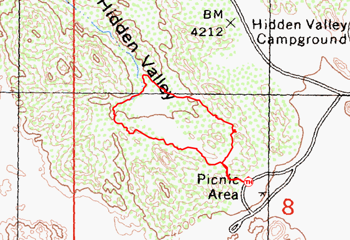
Our first stop was Hidden Valley, just off the main park road. Legend has it that cattle rustlers hid their stolen cattle in lush valleys such as this one as early as the 1870s. The surrounding rock walls not only acted as a natural barricade, but they created a moist microclimate that allowed for an abundance of grasses, perfect forage for stolen livestock.
Hidden Valley was once completely surrounded by rock walls, protected from the outside world. In 1936, Bill Keys, one of the area’s well known landowners, blasted an opening in Hidden Valley’s protective barrier and grazed his cattle on the lush grasses. Unfortunately, the ecosystem wasn’t made to withstand grazing pressure and the valley is now more similar to the surrounding desert than its former verdant state.

“Between the desert and the summit was a region where stolen cattle could be concealed, grazing in rock-bound valleys under watchful eye.“
– Philip Johnston
The trail enters the valley through Bill Keys’ blasted opening and loops around the perimeter. The valley’s unique vegetation is described on numerous interpretive signs along the trail.

Pinyon pine typically only grow at higher elevations but can exist in Hidden Valley due to the increased moisture. Rainfall runs off the rock formations and collects in the valley, allowing for a more dense and varied plant community than the surrounding desert.


The rock formations surrounding Hidden Valley are popular with rock climbers and numerous social trails lead off the main trail to various climbing routes. One short trail led us into a small cave that we spent a few minutes exploring.

Now that the park was waking up, it was time to make our way to our next destination. Hopefully we could find parking!
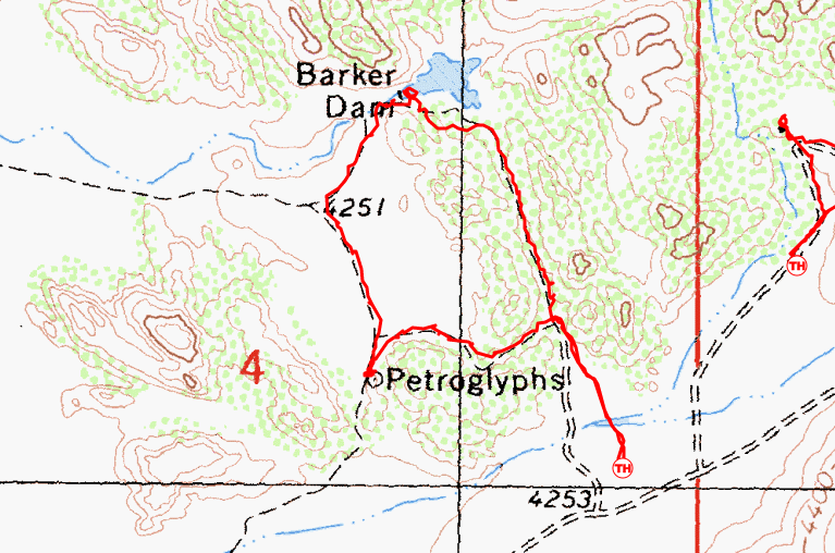
Barker Dam | Joshua Tree National Park
Twentynine Palms, CA | 02/15/20 | 1.63 miles | 69′ gain
I’d heard that Barker Dam was an extremely popular hike so I was worried about finding a parking spot, but thankfully the large parking lot was only partially full when we arrived. A huge (and very loud) group was just about to set off down the trail so we booked it to get ahead of them. I think most of the cars belonged to this 30+ person group as we hardly saw a soul as we moved away from the trailhead.

The Barker Dam Trail is another short loop that visits an historic dam and petroglyphs. In true Joshua Tree NP fashion, numerous signs along the trail identified native plants.


We went counter-clockwise around the loop and arrived at Barker Dam very soon after starting out. Cattle ranching was a very important business in this area from the late 1800s to the early 1900s. The average annual rainfall at the time was around 10 inches. When compared with today’s annual average of 2-5 inches, it was much wetter a century ago. Valleys such as this one were carpeted with lush grasses. However, ranchers still needed more water for their livestock, so they created ways to capture water: wells, dams, and other improvements to expand natural water sources. In 1902, the Barker & Shay Cattle Company laid the lower stone dam to capture water in a natural basin. Bill Keys and his family added the upper concrete portion in 1949-1950.


The reservoir is about 20 acres, but barely held any water when we visited. As the annual rainfall decreased, water sources (and grasses) dried up, forcing ranchers to move on.


We explored the dam and surrounding area for quite some time and found artifacts around every corner. An awesome destination hike and we weren’t even done yet! We continued along the loop, learning about more plants along the way, looking out for the turn off for the petroglyphs.


We finally came to the sign for the petroglyphs, which were just off the main trail. Both petroglyphs (carvings) and pictographs (paintings) have been found throughout the area. We were so excited to see the petroglyphs but learned that someone had painted over the carvings on this panel. This makes them much easier to see, but it’s still vandalism and now we can no longer see the petroglyphs in their original form.


The petroglyph panel was near the end of the loop, so we quickly made our way back to the car and onto our third and final hike in Joshua Tree.

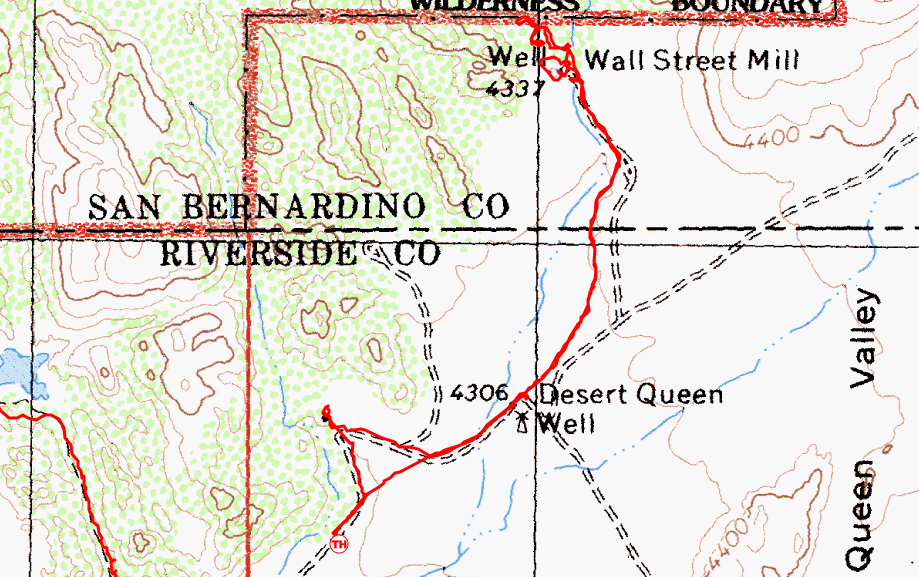
Wall Street Mill | Joshua Tree National Park
Twentynine Palms, CA | 02/15/20 | 2.36 miles | 69′ gain
Strangely enough, I didn’t find any information about the Wall Street Mill in all of my pre-trip research. I happened upon it after we arrived in Joshua Tree and it looked too cool to skip. We had to do a little rearranging and prioritizing, but this one was on the must do list.
Approximately a two minute drive from the Barker Dam Trailhead is the small parking lot for the Wall Street Mill. We snagged the last parking space and set out. (But don’t think that because there was no more parking, people left and parked elsewhere. The lot was PACKED when we got back. People parking off the road, in the road, blocking other cars…it was crazy. I’m thankful we were able to make it out!)

The Wall Street Mill trail sets out across the Desert Queen Valley and eventually makes its way to an old gold ore processing mill, passing historic sites every step of the way!


After about a mile, we reached the Wall Street Stamp Mill. This piece of land has a long human history beginning centuries ago when Native Americans sheltered in the surrounding rock formations. In the late 1800s, a rancher dug a well here which became a popular spot for watering cattle. Miners came in in 1928 and staked a claim on the well site. They built a cabin and named the site Wall Street. They left shortly after, and Bill Keys stepped in in 1930, filing his own claim. Keys built a bunk house, outhouse, and brought in the stamp mill ore crusher. He operated the mill off and on from 1930-1966, processing gold ore from the region’s mines. Keys died in 1969 and in 1975, the Wall Street Stamp Mill was entered in the National Register of Historic Sites.


Numerous trails and washes lead off in all directions, and we spent a long time exploring and climbing on the rock formations. On the way back to the car, we followed a short side trail to the ruins of what appeared to be a stone house. We’re unsure of the origins of this building.


This sadly wraps up our time in Joshua Tree, but this was only part one of our trip. Next up, we’re heading to Tucson! Stay tuned for coming posts!
Chelsea

Wow, what a cool place!! Keep sharing the good times.
LikeLike
Thank you so much! 😀
LikeLiked by 1 person
Great pictures!
LikeLike
Thank you!! 😀
LikeLiked by 1 person
Maps look great!! Great post!! Stay safe and healthy!!
LikeLike
Thank you Lori! Hope you are staying safe as well.
LikeLiked by 1 person
I’ve been there many times and there is still so much more I need to explore, great photos!
LikeLike
Thank you! I can’t wait to go back, it was amazing.
LikeLike
I did not realize there are artifacts. I thought only of trees and boulders.
Thank you for the pictorial coverage.
LikeLike
There is so much history in Joshua Tree! I had no idea how extensive. The dry desert preserves things well, so there is so much to find. There are a couple of ranch ruins within the national park as well, one is so protected that you can only see it on a private tour! (We sadly didn’t have time to visit these, but I’m sure they’re very cool!)
LikeLike
The maps are a great addition! Happy hiking and stay safe.
LikeLike
Thank you! I am glad 🙂
LikeLiked by 1 person
Nicely written, nicely photographed. Maps add an interesting feature. I especially appreciate the scientific names that I believe is a first. Thanks.
LikeLike
Thank you so much!
LikeLike
I read you encountered some loud and boisterous campers. I am just curious. What are your best strategies for practicing social distance precautions as experienced hikers?
LikeLike
I would say that I am naturally averse to human encounters to begin with, so social distancing is not too new for me haha! But in unusual times like these, we can practice a few additional things to maintain our distance.
1) We pick trails that may be less busy. Lesser known, unpopular, etc.
2) Some trails are very wide, like 10′ sidewalks or gravel roads. These are easy to maintain distance because everyone can just stay on their side of the trail!
3) We can go at less popular times of the day, early morning or late evening. (Headlamps may be necessary, depending!) I’m not sure about other areas, but in Colorado most trails are busiest 10am-3pm.
4) When we do find ourselves on a narrow trail that is busy, we will just step off the trail 6′ to maintain social distance. Normally I would never tell anyone to do this, as it can widen trails and trample vegetation, but I do feel like it’s safer than potentially spreading the virus. If rock or dirt areas are available, those are best to step on. Also, just communicate with people. Let them know that you’re stepping off to let them pass safely, or maybe ask them to step off if you’re in a spot that may be dangerous to step off (cliffs, etc.)
5) And of course, there’s the “don’t go at all” philosophy that unfortunately I have a hard time with. It’s definitely the safest, but it’s really important for my mental health to get out into nature. We follow all of the above when we do go out, and we try to stay as close to home as possible, avoiding small mountain communities.
Thankfully, most everyone here has been really understanding and working together to maintain social distance on trails.
LikeLike